
The Apple Watch is a great companion for hikers, allowing them to track their workouts and calories burned. But with recent updates, the Apple Watch can also help find hikes.
Related:
- Downloaded offline trail maps on Apple Watch make hikers lives easier and safer
- Why is my Apple Watch not counting my walks or jogs as exercise minutes in the Activity Ring?
- WorkOutDoors: the most customizable and fully functional workout app for Apple Watch
While Apple’s flagship wearable has long had the ability to track hikes, outdoor walks, and other workouts, the Cupertino tech giant has been steadily making the Apple Watch more useful for outdoor enthusiasts.
For example, the Apple Watch can help you navigate through low-signal areas with offline downloaded trail maps. Of course, there’s also the Apple Watch Ultra — a rugged version of the wearable that’s specifically made for extreme sports and outdoor use.
In watchOS 10, Apple has also included several features that make it much easier to use your Apple Watch to find hikes nearby, and potentially locate other interesting landmarks or attractions. Here’s what you should know.
How to use the Apple Watch to find hikes

As long as your Apple Watch is running watchOS 10, you can use the built-in Apple Maps app on your wearable to find trails in the U.S.
Here’s how.
- Open the Apple Maps app on your Apple Watch.
- Tap the Search icon and type in “trails.”
- Turn the Digital Crown to browse for trails, and then tap on a result to get additional details and directions.
Once you search for nearby trails, each potential hike will show up as a green dot on the map. The name of each specific trail will appear near the bottom of your Apple Watch’s display.
Along with trails near you, you can actually search for trails in other locations. Just use your finger to navigate to another area on the map, tap the search button, and search for “trails.” Instead of showing you hikes near your location, the app will show you trails in the map area.
You can also use Siri on your Apple Watch to find nearby trails with a voice command like “trails near me.”

Importantly, you won’t just see the name of the trails. The Apple Maps app also includes details like:
- Length
- Highest elevation
- Lowest elevation
- Distance from your current location to the nearest trailhead
Similar Apple Watch features
The new trail-finding feature is a complement to existing discovery features on the watchOS version of Apple Maps, including the ability to see local guides and find nearby services from your Apple Watch.
For example, there’s a new topographic map option that will let you see local elevation. That makes it easier for identifying how tough your potential nearby hikes will be!
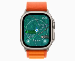
The Apple Maps app on Apple now also includes a walking radius ring, as seen above. The radius ring allows you to see how long it will take to get to nearby points of interest, attractions, trails, and more.
In other words, the Apple Watch is becoming an even greater device for hikers of all stripes. Happy hiking!


